Rethink Your Approach to Street Projects: Save Money with a Pavement Management System
_960x360.jpg)
Pavement Management Systems (PMS) play a significant role in effectively managing and maintaining one of a city’s or township's most valuable and costly assets: their streets. We will delve into the benefits of implementing a PMS and how using Geographic Information System (GIS) technology helps streamline the process of assessing pavement conditions, prioritizing maintenance, and budgeting for street improvements. By shifting the focus from reactive repairs to proactive maintenance strategies, cities and townships can save considerable resources while ensuring safe and well-maintained road networks.
Assessing Pavement Conditions
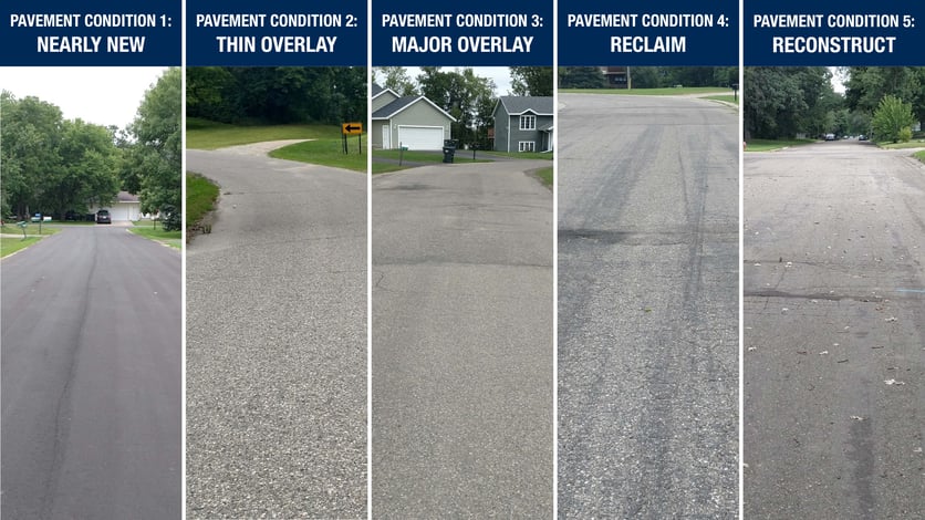
Widseth’s civil engineers conduct a pavement condition survey to initiate the pavement management process. This involves driving through the city or township limits conducting a “windshield survey” of all streets and classifying their surface conditions on a scale of 1-6.
Understanding Pavement Condition Levels
Pavement Condition 1 - New Or Nearly New
These streets have recently been redone or are in overall great condition. They require minimal maintenance, exhibit relatively few cracks, and need only basic surface treatments. Maintaining these streets is inexpensive.
Pavement Condition 2 - Thin Overlay
These streets are still in decent condition but are beginning to show signs of cracking, wear, and degradation. Preserving these streets requires a thin overlay to add strength and longevity. The thin overlay is inexpensive compared to other more work-intensive surface treatments and will restore the street to Condition 1 while adding strength to handle heavier vehicle loads.
Pavement Condition 3 - Major Overlay
Streets in this condition may have undergone previous patching repairs or utility trench repairs. They often exhibit alligator cracking, which requires full-depth repair to fix the problem area(s). The overall ride of the street may also be in poor condition, which would necessitate a thicker overlay. While the cost is higher than Condition 2 due to extra patching and a thicker overlay, it remains manageable.
Pavement Condition 4 - Reclaim
Dominated by alligator cracking, these roads have deteriorated significantly. No amount of overlay or chip sealing can rectify the damage. Reclaiming such streets involves substantial effort, time, and resources. The work includes grinding up the existing street and paving a brand-new street. Some existing asphalt can be reused in the process, which can help mitigate the costs.
Pavement Condition 5 - Reconstruct
At this stage, roads have poor subgrade and a failed surface. These are the worst roads and require complete reconstruction. Reconstructing roads is the most expensive option, involving extensive subgrade repair and surface replacement.
Pavement Condition 6 - Gravel Street
This condition refers to primarily gravel-based streets. While they do not typically require immediate attention, they should be monitored.

Using GIS for Efficient Management
Widseth harnesses the power of GIS to collect, analyze, and visualize data, providing an in-depth view of the intricate street network within a city or township. Armed with this comprehensive map, decision-makers gain valuable insights for efficient resource allocation and informed decision-making. GIS specialists enter the collected data into the system, enabling a spatial analysis that breaks down streets by their respective conditions. By assigning cost values based on factors like length, width, and surface area, GIS generates the cost per condition, serving as a vital compass for budgeting and maintenance planning. With Widseth's GIS technology, local roads and streets become more than mere pathways; they transform into well-managed assets, fostering optimal maintenance and strategic allocation of resources.
Benefits of Pavement Management Systems
Cost Savings
By adopting a proactive maintenance approach and focusing on maintaining streets in good condition, cities and townships can save substantial amounts of money. Compared to the traditional practice of fixing only the worst streets, implementing a pavement management program can save you up to three times the expenditure.
Future Planning
With the aid of GIS, a PMS facilitates long-term planning and budgeting. It assists in developing Capital Improvement Plans (CIP) that prioritize investments and allocate resources efficiently. City officials can make informed decisions regarding expenditures, determining where and when to invest in street improvements.
Public Transparency
A PMS with GIS integration allows cities to develop overlay programs and present five-year plans to the governing board and residents. This transparency builds trust and ensures city residents know the intended maintenance efforts and budget allocations.
Pavement Management Systems, supported by GIS technology, offer cities and townships a comprehensive approach to maintaining their streets. By shifting the focus to proactive maintenance and utilizing data-driven decision-making, cities can save money, extend the lifespan of their road networks, and provide safer and more reliable transportation infrastructure for their residents. Contact Widseth to start the conversation about generating your own Pavement Management System.

Search Archives
Categories
Posts by Topic
- Staff News (98)
- Architecture (66)
- Funding (61)
- Civil Engineering (53)
- Education (48)
- Architectural Design (38)
- Engineering (37)
- Land Surveying (32)
- Surveying (26)
- Environmental (22)
- Commercial (21)
- Interior Design (18)
- Streets & Highways (17)
- Utilities (17)
- Water Resources Engineering (14)
- Industrial (13)
- Community (11)
- Cultural (11)
- Landscape Architecture (11)
- Sports & Recreation (11)
- Government (10)
- Aerial Mapping (8)
- Mechanical Engineering (8)
- GIS (7)
- Electrical Engineering (6)
- Structural Engineering (6)
- Senior Living (5)
- Transportation Engineering (5)
- Bridges (3)
- Site Design (3)
- Transmission & Distribution (3)
- Healthcare (2)
- Planning (2)
- manufacturing (1)
Recent Posts
-
May 06, 2024


